
| November 3, 2025 | No.199 |
October 2025
(Back Issues Here)
We had 35.80 inches of rain at the Palmira Arriba Station during the month of October 2025.
Rainfall for October 2025 |
|||
Area |
Contributors |
October 2025 |
Total 2025 |
| El Salto Arriba | Beth Corwin | 20.28 | 89.44 |
| Bajo Lino | Rodrigo Marciacq | 22.82 | n/a |
| Los Cabazos | Don Hughes | 19.58 | 85.43 |
Jaramillo Arriba |
Steve Sarner |
38.83 | 152.49 |
| Jaramillo Arriba | Mark Heyer | 35.80 | n/a |
| Jaramillo Alto | Steve White | 39.29 | 154.82 |
| Jaramillo Central | Colleen Anderson | 22.51 | 85.93 |
Jaramillo Abajo |
John McGann |
43.20 | 155.34 |
| Palo Alto | Nancy Pettersen | 23.35 | 104.04 |
| Valle Escondido | Gisela Remsen | 27.88 | 94.42 |
| Brisas Boquetenas | Dennis Decorte | n/a | n/a |
| Brisas Boquetenas | Richard Sturz | 63.42 | n/a |
| El Encanto (Volcancito) | Brian Baldwin | 29.96 | 108.24 |
Cerro Verde (Volcancito) |
Charlotte Lintz |
23.37 | 84.19 |
| Caldera | Chris McCall | 30.92 | 160.57 |
| Lucero | Mike Joy | 55.37 | 214.83 |
| Palmira Abajo | Dave Nichols | 42.10 | 164.67 |
Palmira Arriba |
Lloyd Cripe |
35.80 | 130.98 |
| N/A = Not
Available Red = Highest rainfalls Green = Lowest rainfall |
|||
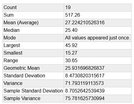
Checking the past data from the Palmira Arriba Station over a span of 19 years, the average rainfall for the months of October is 27.22 inches. The range is a low of 15.27 inches to a high of 45.92 inches. This month's 35.80 inches is 1.01 standard deviations above the mean compared to the means for October. So we had more rain in October than we normally expect but only one standard deviation above the normal statistical range. October is usually one of the rainiest months of the Rainy Season. In 19 years we have had 5 Octobers with this much or more rain. In October of 2011, we had 45.92 inches of rain! It was a year when we had serious flooding.
Palmira Arriba Station Average October Rainfalls over 19 Years
At the Palmira Arriba Station we had 28 days with measureable precipitation and 3 days without.
The table above with the rainfall in various parts of the district of Boquete for October shows levels from 19 to 63 inches. This is a lot of variation. Check it out to see who gets the prizes for most and least rainfall in October.
The average winds at the Palmira Arriba station were 0.53 mph and generally from the NE. Our maximum wind gust was 15.5 mph. This was the lowest monthly average winds for the year as expected in the rainy season. Average temperature was 65.99 degrees F. The Highest temperature was 82.1 degrees F. Lowest temperature was 57.6 degrees F. You can check all of our (Palmira Station) previous data for the months of October over the years at this link.
The latest ENSO Cycle Report is saying that "La Niña conditions are present. Equatorial sea surface temperatures (SSTs) are mostly below average across most of the Pacific Ocean. Atmospheric anomalies over the tropical Pacific Ocean are consistent with La Niña. La Niña conditions are present and favored to persist through December 2025 - February 2026, with a transition to ENSO-neutral likely in January-March 2026 (55% chance)..."
Here is a link to a source to better understand El Niño in case you need some help interpreting what this all means. Give this a read and you will learn a lot about this important weather phenomenon that affects global weather. It has more effect upon the Northern Latitudes than it has upon us here in the tropics.
The IRI (International Research Institute for Climate and Society) (select South America from the Region menu) is predicting a dry season with a 50% probability of Above Normal rain in some parts of Panama and in other parts a 70% probability of rain during the months of November - December - January 2026 (mostly Green with some areas of Blue).
.jpg)
IMHPA (Instituto de Meteorología e Hidrología de Panamá) documents section predicts that during November "...It is anticipated that accumulated rainfall will increase slightly in the province of Bocas del Toro, northern Veraguas, the Costa Arriba region of Colón, and some areas of Los Santos. For the rest of the country, rainfall is expected to be within the normal range for the month. Meanwhile, the provinces of Chiriquí, Coclé, Panamá Oeste, the Ngäbe Buglé Comarca, and central Veraguas may experience slightly below-average rainfall." You can read their entire report and check out the details in the "documents" section at this link.
October came through as it often does with lots of rain. The month started with some heavy rains in some areas on several days and resulted in some flooding in parts of the Boquete District. A number of creeks were gorged with water and overflowed. Water ran down and over streets. There were areas where landslides occurred obstructing some roads. The larger rivers rose but fortunately did not overflow. There was not a major flood like experienced in Boquete in past years. The recent flooding was more like flash flooding with some landslides in vulnerable areas.
Why were there some days with heavy rains. The rain was the result of tropical systems in the Caribbean. When these systems form north of us they, especially if close by, bring lots of precipitation that can fall on us if the storms are big enough and close enough to us. Being nestled between mountains, Boquete often gets lots of drainage coming off of the mountains. The rain water from high in the mountains has to go somewhere so of course it goes downhill to the Boquete, especially into the Bajo Boquete areas. Streams can rage and cause rapid erosion loosening soil and in some areas triggering landslides.
We don't typically get hurricanes passing through Panama, but we do experience precipitation from some of the tropical storms that develop north of us in the Caribbean.
I have heard some mentioning "Atmospheric Rivers." It may seem like a river falling out of the sky onto you when a tropical downpour happens but these downpours are not Atmospheric Rivers. We can get several inches of rain quickly. Normally each year we will have some days of 3-6 inches of rain in short order. I have seen 6 inches of rain fall within a couple of hours. These days can lead to flooding.
On October 10, Mark Heyer posted on the Facebook Boquete Weather Network a forecast that on late Friday and the weekend "...An atmospheric river is bringing a massive amount of humidity from the Pacific ocean right at us..." He posted a graph he apparently made from an Earth snapshot with headings predicting an Atmospheric River. I asked him to clarify who had made this forecast. It was obvious that it was of his making. I couldn't find any reliable sources making such a prediction. I watched and waited for several days but no Atmospheric River showed up. We didn't even have any heavy rains.
Why didn't they show up. Mainly because the prediction was being made by an inexperienced weather forecaster. Also because Panama is not in a part of the world that experiences Atmospheric Rivers. Before we moved to Panama in 2005, we lived in the Pacific Northwest where we experienced such storms. I haven't seen anything like an Atmospheric River while living here 20 years.
A quick check with the Google Search AI asking, "Does Panama get Atmospheric Rivers?" stated:
Panama does not typically experience the type of intense atmospheric rivers that make landfall in the mid-latitude regions, such as the west coasts of North and South America, Western Europe, or Southeast Asia. Atmospheric rivers are generally associated with extratropical cyclones that transport moisture from the tropics toward the poles, usually impacting areas located around 30° to 60° north and south of the equator. Panama is located in the low intertropical latitudes, between 7° and 9° North latitude.
- The Intertropical Convergence Zone (ITCZ), a persistent band of low pressure and associated disturbances that is the main driver of the country's rainy season.
- Cold fronts that occasionally penetrate from northern latitudes.
- Tropical waves and low-pressure systems in both the Pacific and Caribbean Sea.
A quick look with Perplexity AI with the question: "Does Panama get Atmospheric Rivers?" states the following:
Based on the search results, Panama does experience strong atmospheric instability and heavy rains triggered by regional circulation systems like the Intertropical Convergence Zone and disturbances from cold fronts. These systems bring convective activity and rainfall due to Panama's position between two large bodies of water and its complex orography. However, atmospheric rivers, which are concentrated narrow corridors of water vapor typically occurring in the extratropics and known for bringing heavy precipitation to regions like the western United States are not specifically mentioned as a weather phenomenon affecting Panama. Atmospheric rivers predominantly occur in extratropical regions rather than the tropics where Panama is located.
Therefore, Panama does not typically get atmospheric rivers as they are generally a phenomenon of higher latitudes, but it does experience intense tropical rainfall from other meteorological processes linked to its tropical location and regional climate features.
In summary, Panama is not a region where atmospheric rivers occur, but it has its own distinct tropical rainmaking systems driven by local and regional atmospheric conditions.
If you want to understand our rainy season and why we get some heavy rains I suggest that you study the tropical systems that come our way mainly from the Caribbean. A good source for following these systems is The Weatherman - Brian Shields. He is a well trained highly experienced meteorologist specializing in Caribbean weather. His daily reports are helpful for following weather that can affect us.
We all would like to know what is going to happen with the weather before it happens. While there is a lot of information on the internet that can be useful in understanding our weather and trying to be prepared for it, there are no weather prophets or messiahs who can read crystal balls and guide us. With some effort and diligence we can follow the weather and get some idea of what may transpire in our area from the science and practice of meterology, but beware of unreliable sources and false prophets. Weather Chat groups can generate a lot of unreliable chatter and opinions.
Regarding preparation for heavy rains, the best thing to do is not live in flood plains or near waterways that might overflow. Be sure you have a good drainage system for your house and property. A good roof helps too!
October did not disappoint. We got more than enough rain. November will bring rain but hopefully not as much. Keep the umbrellas handy.
Lloyd Cripe