| February 3, 2026 | No.202 |
January 2026
(Back Issues Here)
We had 0.07 inches of rain at the Palmira Arriba Station during the month of January 2026.
Rainfall for January 2026 |
|||
Area |
Contributors |
January 2026 |
Total 2026 |
| El Salto Arriba | Beth Corwin | 0.17 | 0.17 |
| Bajo Lino | Rodrigo Marciacq | n/a | n/a |
| Los Cabazos | Don Hughes | 1.17 | 1.17 |
Jaramillo Arriba |
Steve Sarner |
n/a | n/a |
| Jaramillo Arriba | Mark Heyer | 1.29 | 1.29 |
| Jaramillo Alto | Steve White | n/a | n/a |
| Jaramillo Central | Colleen Anderson | 2.0 | 2.0 |
Jaramillo Abajo |
John McGann |
0.34 | 0.34 |
| Palo Alto | Nancy Pettersen | 6.49 | 6.49 |
| Valle Escondido | Gisela Remsen | 0.20 | 0.20 |
| Brisas Boquetenas | Dennis Decorte | 0.14 | 0.14 |
| Brisas Boquetenas | Richard Sturz | 0.00 | 0.00 |
Cerro Verde (Volcancito) |
Charlotte Lintz |
0.37 | 0.37 |
| Caldera | Chris McCall | 0.00 | 0.00 |
| Lucero | Mike Joy | 0.08 | 0.08 |
| Palmira Abajo | Dave Nichols | 0.02 | 0.02 |
Palmira Arriba |
Lloyd Cripe |
0.07 | 0.07 |
| N/A = Not
Available Red = Highest rainfalls Green = Lowest rainfall |
|||
Checking the past data from the Palmira Arriba Station over a span of 20 years, the average rainfall for the months of January is 0.75 inches (3/4 inch). The range is a low of 0.00 inches to a high of 3.18 inches. This month's 0.07 inches at the Palmira Arriba Station is -0.73 standard deviations below the mean. So it is less than a standard deviation below normal. Given the small numbers, this is essentially within the average for the month. We had a low but normal rainfall in January. This is the Dry Season and to be expected.
Palmira Arriba Station Average January Rainfalls over 20 Years
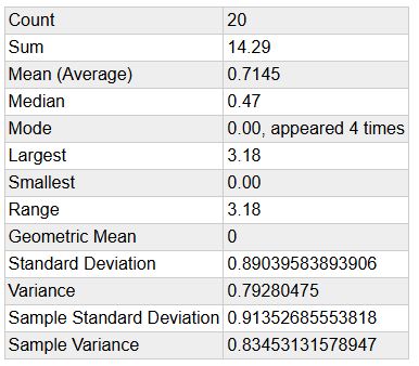
At the Palmira Arriba Station we had 3 days with measureable light precipitation and 28 days without any precipitation. Our total rain for the year 2026 is now 0.07 inches, just beyond 1/6th of an inch mark on a ruler. Keep in mind that the average rain in January over 20 years of observation is only 3/4 of an inch.
The average winds in January 2026 at the Palmira Arriba station was 7.05 mph and generally from the NE. Our maximum wind gust was 25.4 mph. Average temperature was 68.05 degrees F. The Highest temperature was 79.5 degrees F. The lowest temperature was 58.3 degrees F. You can check all the previous data for the months of January at this climate link.
The latest ENSO Cycle Report is saying that "La Niña is present. Equatorial sea surface temperatures (SSTs) are below average across the eastcentral and eastern Pacific Ocean. Atmospheric anomalies over the tropical Pacific Ocean are consistent with La Niña. There is a 75% chance of a transition to ENSO-neutral during January-March 2026. ENSO-neutral is likely through at least Northern Hemisphere late spring 2026."
The IRI (International Research Institute for Climate and Society) (select South America from the Region menu) is predicting above normal precipitation in Panama has a 40+% probability of normal precipitation during the months of February - March 2026 - April (White areas).
.jpg)
IMHPA (Instituto de Meteorología e Hidrología de Panamá) documents section predicts that during February "...It is expected that accumulated rainfall for this month will increase in the province of Bocas del Toro, the Ngäbe Bugle Comarca, northern Veraguas, the lower coast of Colón, and southern Darién. Typical rainfall for the month is expected in the rest of the country." You can read their entire report and check out the details in the "documents" section at this link.
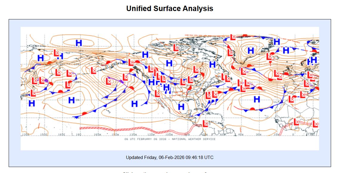
You have probably noticed that the winds are becoming stronger. The ITCZ is currently over Panama and further south. As always, the ITCZ is a zone of lower pressure. The Polar Vortex has dipped down tending to deliver high pressures and cold fronts and brings cold weather (like they are experiencing up north). If we look at the current United Surface Analysis chart we see Low pressure over Panama and a lot of High pressure north of us along with cold fronts (dark blue triangles). Note also the big blue H over the Atlantic to our northeast (Bermuda High or Azores High). High pressure moves air toward low pressures. This combined with the rotation of the earth produces our NE Trade Winds. So we are now getting lots of wind mostly from the NE. Other factors affect exactly how much wind you will get in your particular location. Read more about our winds here.
I recently noticed looking south from our patio more interesting high wispy cirrus clouds. These clouds are interesting to see. They form when warm air rises and ice crystals form in the higher cold windy air. The high winds spread the clouds out. Some of these cirrus clouds that are very wispy are commonly called "Mares Tails."
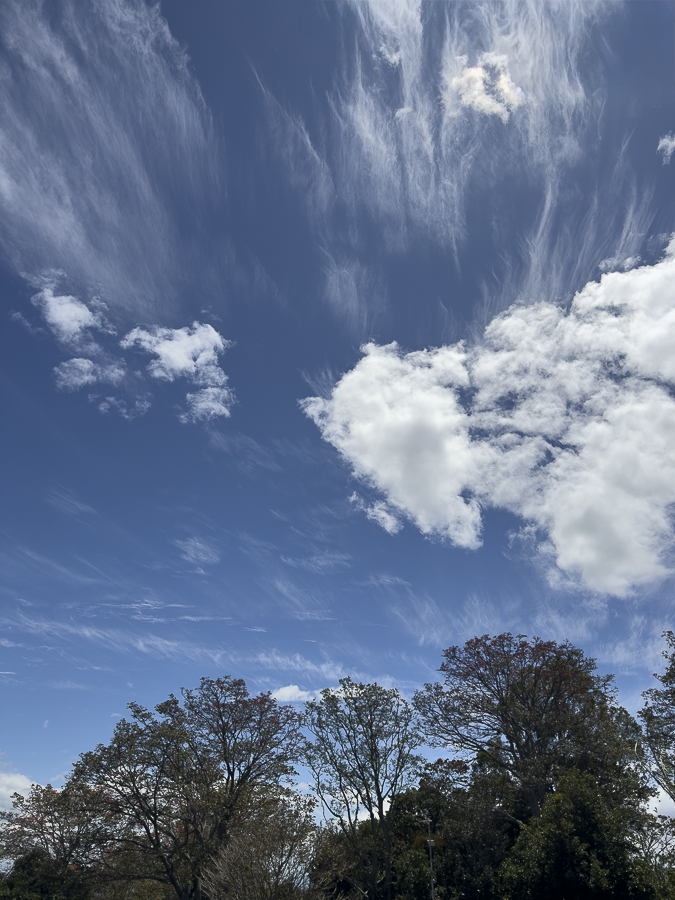
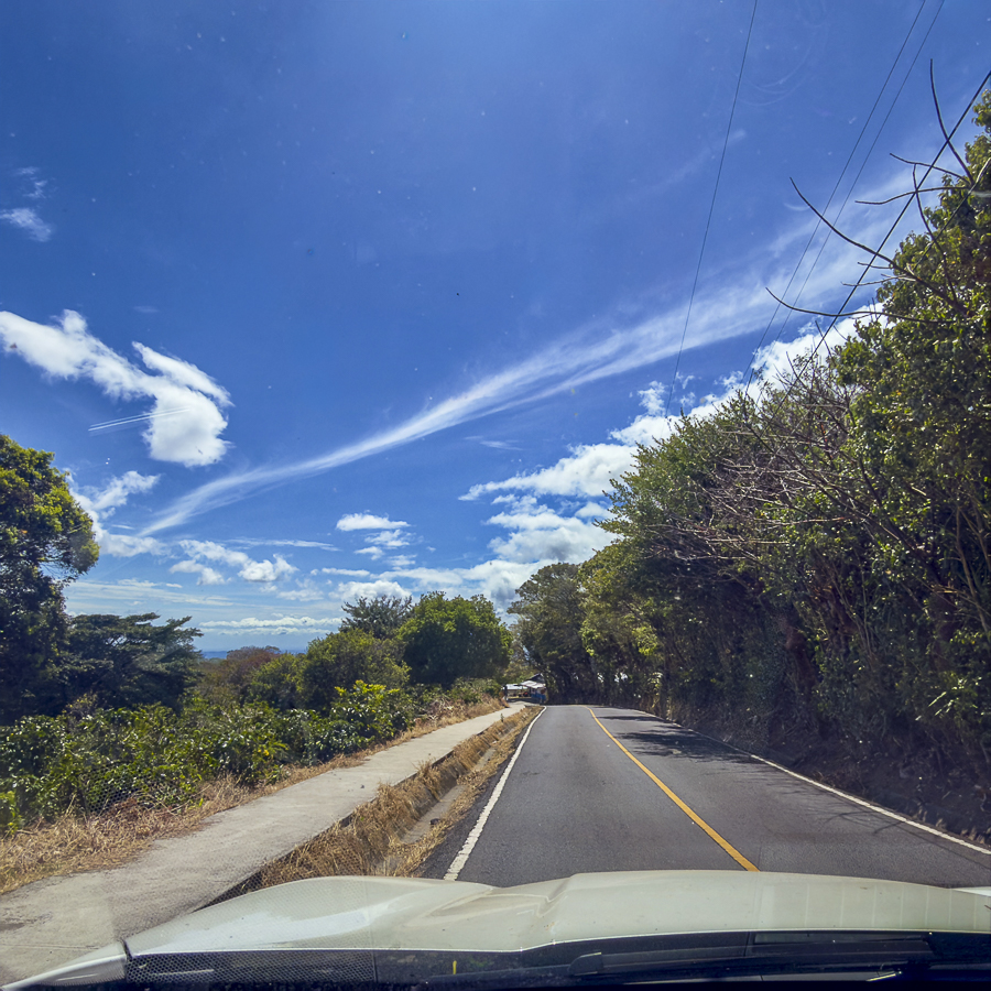
Sunday while heading south toward Palmira Central we saw a line of high cirrus clouds in a streak across the sky. It wasn't a contrail. It was a line of high cirrus clouds caused by the winds and pressure interactions.
It is definitely Dry Season weather and it is windy. Enjoy all the sunshine you can. February should bring a bit more moisture and plenty of wind. Keep looking up at those interesting clouds. Also be grateful that you are living in Paradise with a bit of dry weather and wind and you are not wearing a parka and shoveling snow!
Lloyd Cripe